Easter was here so of course Chris was working it! I had planned on doing a Pendle or Amble walk on Good Friday but the weather conspired to make me stay at home and be harassed by the cat…and my PC! Likewise Saturday was off the agenda as well and on Sunday we had a family get-together to attend. This left just Monday but I do like walking on Bank Holiday Mondays.
So, having called in at McDonalds for breakfast with Chris and then dropping her off, I went home, got ready and left the house to head to Rivington, Pendle could be saved for the next bank holiday.
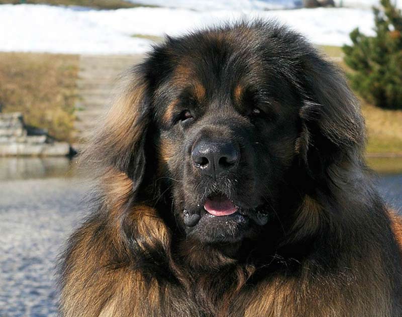
Eventually, I left the car parked at Rivington Barn at 10:48 and headed straight down the lovely wide, hardly ever utilised driveway which leads to the heart of Rivington – okay it is not a big heart, shall we just say the part which features the village ‘Green’ and tea room! The plan was to do part of the Anglezarke Amble in reverse. This meant starting at the end – the end of the Amble that is, on Sheep House Lane. From here I tip-toed around the mud, dropped down a staircase and ambled along side the Dean Brook and into the Yarrow Valley. The Yarrow Valley is considerably bigger than the River Yarrow itself, so to pinpoint me I should indicate that I was walking past the western edge of the Yarrow Reservoir. Many dog walkers were out today and I caught sight of one family whose ‘Labrador’ looked to be on the big and frisky side. It was only when I caught up to the group that I discovered that the dog was far less commonly found than a mere Labrador. The dog was in fact a Leonberger. And it was big softie – thankfully. I spent a few minutes talking to the family and discussing my belief that the ‘thing’ which attacks me (and anyone else who passes it) on Catherine Edge is a Caucasian Shepherd (a bloody angry one at that!).

Having bid my farewell to the family and its gorgeous dog, I took a left when facing more or less half way along the embankment of the Yarrow reservoir and into territory that I had never previously ambled in – in this direction. So I was extremely happy to identify the water chute from the Yarrow. This is generally an uplifting sight when doing the route the other way around as it indicates there is less than a mile to go. Today it served to indicate that I had not (yet) got lost. I descended the slope, turned right and crossed Knowsley Lane. The Anglezarke Reservoir sprawled out majestically on my left hand side whilst the odd cyclist passed on my right. I wasn’t on this section of road for long as soon enough I took a left in order to skirt around the Anglezarke Reservoir some more instead of bearing with the road. From here onwards the terrain became more rural and more sylvanian as I passed through various sections of the woods which cover a large section of this area. Again, another ‘Amble’ landmark – ‘the cowpat path’ filled me with memories of my first time of traversing this route in february of 2016.
It was around this time when I came to notice a walker behind me who was beginning to catch up to me – but not in a creepy / stalking sense. Within a few moments, as I was deciding whether to go left or right, another couple of dozen walkers caught up with us both. I enquired as to the destination of the left hand path and the lady whom I had asked advised me that it would lead to White Coppice – a result!

The lady was one of a number of walkers out that day from the East Lancs L.D.W.A. We spent some moments walking very briskly and chatting away about the walks that this group organises. I was a member of the West Lancs group…but with regret I had let my membership expire. The group’s walking speed was militarial – I’d hazard a guess that we were doing at least 4 m.p.h. through the woods on route to White Coppice. I did notice that the banter of the group was very relaxed, somewhat mildly ribbing each other, and genuinely high spirited. As there were also a number of dog walkers with the group this did lead to some more pedestrian style and gate traversals – memories of 2012’s Pendle Witch Walk came flooding back in glorious technicolour. All the same, we made speedy process to White Coppice where I bid my farewells boasting ‘I’m off up Great Hill now…’ this seemed to impress nobody!

The route from just passed Stronstrey Bank, to the rise of Great Hill was actually surprisingly busy. It appears that this is the preferred route of ascension for Great Hill, I think I counted twenty or so other walkers. This rise used to be a fearful one for me…the spectacle that was Steel Fell last December has since toughened me up and I now no longer feel quite as fearful of this grade three climb. That being said, it still gives ones’ calf muscles a good old tune-up. I was trying not to go flying up the hill as this can upset other walkers and well it tires me out quicker and by this time I had only walked something like five of my intended twelve miles. Of course it’s always nice to pass people who are obviously much younger and fitter than oneself and if they just happened to be two young women in their twenties and wearing completely inappropriate footwear – Wellies – for Great Hill??? then this only added to the pleasure.


In time I joined up with a lovely couple from Bromley Cross in Bolton. Our paths had crossed a couple of times at the start of the climb and on the first rise, now I decided to have a good old natter and they were great company, it was especially nice reminiscing about my times in Bolton. As the couple were not in any particular hurry – I can never say the same when I have to get back for Chris, I decided to put my foot down at something like a half mile’s distance from the ruins of Drinkwaters. Funnily enough, three more walkers were draped over these ruins which changed my mind about having a rest here. Great Hill was now looming just around an exceptionally large corner!

Now I decided it was time to make a strident bid for the summit. It was twelve fifty

five and I wondered if I could make it to the top of Great Hill for one o’clock. The answer was a resounding “no!” Once more, I had fallen for the trap of thinking I was closer to Great Hill than what I really was – all the same I did get there by five past one so all credit to me I believe. By this time I had walked almost six miles, over various types of terrain and up a fairly steep incline. To say that I was impressed with my performance was understating things: I had a celebratory flask of coffee at the summit As I was about to leave, the other seated walkers were somewhat insular, continuing to talk amongst themselves as opposed to engaging me, my lovely couple from Bromley Cross summited the slope. Of course we then took each other’s photos and I gave them my web site address (wonder if they’ve visited!).
The time to leave the summit had approached, once more I bid my farewells and set off due south in the direction of the looming giant of Winter Hill and its associated ironwork (the many masts). I knew this to be an easy route – as long as the visibility held up (it did) and I frequently reached for my pocketed camera in case last year’s deer should happen to spring across Anglezarke Moor in front of me (it didn’t!). The slabs laid across the moor some years ago have definitely settled in place now. It was possible to observe where the moorland has started to reclaim the space they have invaded as the cottongrass and ubiquitous water vy for dominance over the grey stone outsider presence. Nature seldom simply accepts what man has willed upon it and I do doubt whether these facilitating stepping stones which snake across the moor, will still be so useful (even accessible) in another fifty years?


It did seem to take just as long to reach the bottom of Great Hill than it did for me to reach the highest point of my route at the top of Spitlers Edge. I had dropped down by a mere twenty metres or so, but to my legs it seemed like much more when I was climbing up Redmonds Edge followed by the gentlest of all ascensions of Anglezarke Moor’s highest ground. From here there would be a very pleasant drop down to Higher Anshaws – parallel to Will Narr, as the paved route has now been extended to just short of Rivington Road. It has to be said, this was easy walking. I had already decided that I would not be bagging Winter Hill again today, no matter how tempting the prospect might be. I had another climb to tackle today and this would certainly test my fitness.


On the corresponding walk last year I noticed a path that had not previously engaged my curiosity. It seemed to start in a hollow area of land just next to Rivington Road and climbed up quite rapidly to Catter Nab near the beginning of the path to Noon slack. Despite visiting the area another few times, I had managed to stave off the traversal of this path…until today. Since the very start of today’s walk I had known that I would be attempting this new diversion and now was the time to set feet on what proved to be the hardest section of this round.
Even the descent was difficult as all around was a somewhat sheer drop and ubiquitous mud to send me sliding to a watery end. I had no alternative than to take my time, pausing frequently to catch my racing breath. The very obvious path vanished from in front of me and reappeared at the other side of a minor brook. The crossing of this watercourse was not difficult and before long I was on another path altogether and heading along to the newly planted area of saplings destined to cloak the hillside in a deciduous shroud. Yet another path ran off at a right angle on my left and I duly followed it up into a sylvanian ascent the likes of which my tortured calves are still not thanking me for! This was hard going. Not only was the slope steep but it was decidedly slippery in parts. I was following three dismounted mountain bikers up the incline, one of which, at the top of the climb dubiously informed me – ‘there’s no right of way here mate, you’ll have f’t climb over’t fence’. Once I’d despatched with my walking pole and bag, the fence proved to be no obstacle and thankfully I was now on the path which I had hoped would be here…Catter Nab to Dovecote.


For the record, as far as paths that are comfortable to walk on – forget this one, it’s horrid! Not only does this path turn into a stream every so often, it is undulating on a microscopic scale, no two adjacent stones are on the same horizontal level. This is not a path after which your feet will thank you. From here i continued my weary way down towards the Pigeon Tower and then for some reason, which escapes me, I turned right and headed towards what I already knew was an even worse, even more bumpy path which I have come to name “Boulder Road”. This section of the route is largely rocks and recycled tarmac as well as various other surfaces. It’s direct, I can remember directly falling here on a number of instances. But, as it is a short section, somewhere, in the now emerging sunshine, was a treat for me. Last year, when I walked a similar route I was tormented by the prospect of a refreshing and well-earned ice-cream, for which I did not have enough time to queue-up and buy.


This year, I did! Even though the queue was small, it still took the best side of ten minutes to get served. Perhaps, being at an altitude of around four hundred feet above sea level was muddying the minds of the waiting patrons. I’m not a psychologist, I do not know, but for whatever the reason the delay was a factor for as long as I did not have my ice cream…then it paled into insignificance. This year I did have time to queue-up, this year I hadn’t got stressed out by the mighty throng ambling their insanely slow way up Rivington Pike and this year I hadn’t had the living daylights frightened out of me by that insane dog on Catherine Edge or had a minor mud bath at Greenhill Farm…this year I’d earned that damn ice cream!
Total mileage = 11.75
Ascent / descent around 1,500 – 1,800′
Terrain – so many!
Song of the walk – again the fantastic ‘I need to forget’ by the wonderful Joanna Koziel and Chris Nahorny.
I’ll be back next year!!!
Five star walk.